M’muock (Fosimondi) village is at the central part of the “M’muock plateau”. The undulating plateau is an extension of the western slope of the Bamboutous caldera. It is situated at about 2470 meters above sea level and between longitude 10° and 10°50′ east of the prime meridian and between latitudes 5°30′ and 60°40′ north of the equator. It is at the extreme North West of Alou sub division in Lebialem Division, South West Region of Cameroon. It has a population of about 17, 000 inhabitants. This beautiful grass field area is bounded on the west and north west by Bamumbu village. South west by Bechati village, south by Folepi village, south east by Besali village, east by M’muock Mbei village, north east by Fongo Tongo, Bafou villages and to the north by Bangang. Fongo Tongo, Bafou, and Bangang are Bamilike villages of Western Region, while the other villages are found in Lebialem Division, South West Region.
Revised by Nwomba Alphones
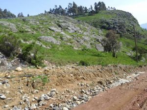 M’muock (Fosimondi) kingdom is made up of mostly igneous and sedimentary rocks, with a larger proportion being igneous (about 85%). The igneous rocks are mostly the basaltic type. The upper part of the kingdom is made up of mainly grassland vegetation, while the lower parts of the kingdom are made up of medium to thick forest vegetation.
Source:
Njofie Wilson (PCEG Geology, Assistant Coordinator/head of IT team of MUNED)